EyeViAsset and Vehicle Location |
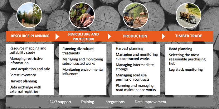
Lower work and transportation costs through smarter planning and transparent resource management.
Reach-U has developed forestry sector applications for more than ten years. This long-term co-operation with both state and private forestry companies has given us understanding in which stage and what type of applications help to bring extra value through work optimization. Besides our expertise in software development, we have focused our work on getting information from new data sources mainly related to satellite imagery. Reach-U is the main distributor of commercial satellite imagery in the Baltic States for Airbus Defence & Security, Blackbridge and Digital Globe remote sensing products.
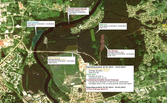
We have developed algorithms that can use Copernicus satellite data with rapid updates and country level coverages to provide information about the forests. With weekly updates we can show where forests have been cut, damaged (wind, fire) or give overviews of forest inventory data (physical forest area, height, stem volume). Based on different commercial satellite data and combing it with free license Sentinel 1a time series, Reach-U provides several services for the forestry sector. Have a look at some examples below. Annual forest mask of a country and timber volume One of the most simple tasks - getting information about where forest is growing and where it is not - is already a challenge when taking into account different owners, land use and updates to forest coverage that take place on a daily basis. With the usual time plan of the forest registry, the updates about changes in the forest are received in 2-5 years (depending on country-specific laws). Mapping the forests that grow on the farmland or other land not registered in forest cadaster takes even in longer, sometimes 10 years or more. With the combination of multispectral and synthetic aperture radar data, Reach-U provides locations of the forests (not affected by update status of country level registries) together with stem volume (main attribute to distinguish forest from non-forest). With this information end-users (forestry companies and National Forest Agencies) can determine locations of forest areas, validate registry data with satellite data feed and evaluate forest stem volume for planning. Take a closer look at the service demo. Forest change detection on a weekly basis (human activity and storm damages) Reach-U offers unique information feed by providing forest change detection over large areas (100 000 km2 and more) with weekly updates. This can be done by using Sentinel 1a data as a source and automated processes to extract information about the changes from the satellite data time series. The result is similar to forest monitoring from multispectral images (Lansat8, SPOT6, WorldView3 etc.) and manual labor work but the frequency is 10-15 times higher and cost per hectare 4-5 times lower. With this information end-users can react quickly in case of forest damages, prioritize forest logging areas and evaluate storm damage for resource management. Example of a weekly report: Take a closer look at the service demo.
Annual forest height map with monthly change detection updates With regular activities in the forest management sector and based on the fact that forests grow each year, there is a constant need to update the forest inventory data (height, species and volume). This information is crucial to decide what management techniques and activities can provide highest productivity and protection of forest at the same time. Reach-U provides a more efficient alternative to forest height estimation than LIDAR mapping with airplanes and drones or fieldwork. With the use of TanDEM-X sensor (Airbus D&S) and automated processes we can provide 1m accuracy forest height map with minimum mapping unit of 3m. The cost per hectare is about 2 times lower than using regular methods for forest height mapping. Take a closer look at the service demo. |


