Mapping for Ordnance Survey
The need for highly accurate and detailed 3D visual data has grown essentially in several segments. Infrastructure management, city planning, spatial data management, digital twin and BIM are only few segments that already include 3-dimensional content over basic GIS data in their processes.
Automotive industry with the development of autonomous cars, delivery robots and drones will soon grow as one of the major users of this input with the need of HD (high definition) map data services.
One of Reach-U’s core businesses is a mobile-mapping service that combines 360 imagery and 3D LIDAR data together with the AI based feature extraction processes to produce detailed visual intelligence. This year we were chosen by the British Ordnance Survey Ltd to be part of a pilot-project which may turn out to be something much bigger.
Who are they?
Ordnance Survey is a limited company in which the entire share capital is owned by the Department for Business, Energy & Industrial Strategy (BEIS). It is the national mapping agency of Britain and is responsible for the surveying, production, maintenance, and marketing of a wide range of geographic information, relied on by government, business, and individuals.
What they wanted?
OS is looking at how this can be achieved through a methodology that is scalable to a national extent using an innovative, highly efficient and automated technology. An operational solution is therefore sought that will not only facilitate initial data capture and feature extraction but permit rapid and regular update and maintenance.
So, the Ordnance Survey needed service providers to support its investigative work into the potential uses of street-side feature geometry and associated attribution to meet various use cases; CAV (Connected Autonomous Vehicles), radio signal propagation and utility operations for example.
What was the tender about?
The Ordnance Survey decided to start with a small tender, a pilot-project, to collect information about who offers this kind of service and learn about possible ways to scale the tiny project to a nation-wide job. A little bit over a hundred kilometers of road in Romney, Southampton and Bournemouth, England, were chosen for the winners of the tender to show what they are capable of.
There were four winners, one of them Reach-U. The Ordnance Survey wanted the four chosen participants to present their raw data gathered via mobile mapping in 360 imagery, lidar data, positioning information (GNSS, IMU, Ground Control Points) or any other data captured by the mobile mapping system used.
What needed to be mapped?
The Ordnance Survey decided to collect all the information that can be gathered as a 3D vector dataset including road furniture, navigational info, objects and vegetation.
But even they did not know, what kind of information the companies involved are able to get. So, they divided the attributes needed to gather into “mandatory” and “desirable”. The first was obligatory and the second would be bonus. There were 23 mandatory and 14 desirable attributes. Spoiler alert, though! Reach-U, who have developed their HD-mapping solutions by themselves, did gather information about 37 out of 37 attributes the Ordinance Survey wanted.
Lamp posts, traffic lights, road signs, street signs, bus stops, pedestrian crossings and many other very important factors in everyday road traffic were made mandatory.
Foliage/vegetation, underpasses, bridges, advertising-boards and so on were made “desirable”, because they did not know if it was possible to gather detailed information about these objects.
How did Reach-U do it?
Gaspar Anton, the EyeVi business Line manager in Reach-U, describes in detail how Reach-U solved the assignment:
“After being one of the four winners of the tender, Reach-U needed to work their magic on the 120 kilometers. We packed our technology into a suitcase and flew to Britain. Then we rented a vehicle and attached the mapping system onto the car.
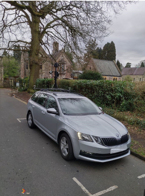 | 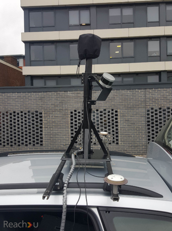 |
Now that we had gathered the raw-data – panoramic images and 3D point cloud – we needed to use them to digitalize the 37 attributes. We had done comprehensive research and development to find a software solution to help us. We chose TopoDot, which is a semi-automatic feature extraction solution based on top of Bentley MicroStation. A person is needed to confirm, change or improve the info given by the software. It took three people a month to verify and confirm 120 kilometers of complex information. Now we had a vector-line with all the necessary information.
Let’s take a curbstone for an example. We now had information of its height and material. Or a traffic sign – there now has information about its type, impact description and direction. And all the features now also include high accurate 3D position information (less than 10cm x,y,z). That’s what we gave to the Ordnance Survey.
Reach-U have bought together what others might call toys and develop them so that top of the notch mobile-mapping can be done as cost-effectively as possible. It is important, because if you want self-driving vehicles to drive on your roads then you need to map the whole country the way UK wants to do it and keep it constantly updated. We are using the same technology and equipment to map right now about 41 000 kilometers of Estonian roads in 2019.
Read more about the solution or our projects from EyeVi.
Get in contact with us:
Gaspar Anton| Business Line Manager
[email protected] | Mob: +372 5330 9423
www.reach-u.com|Reach-U